

“The paths and walks that have been developed over the years have improved conditions for pedestrians and cyclists... but do not represent a connected system or network that serves non-motorists throughout the community,” the project description reads.
This item is available in full to subscribers.
To continue reading, you will need to either log in to your subscriber account, or purchase a new subscription.
If you are a current print subscriber, you can set up a free website account and connect your subscription to it by clicking here.
If you are a digital subscriber with an active, online-only subscription then you already have an account here. Just reset your password if you've not yet logged in to your account on this new site.
Otherwise, click here to view your options for subscribing.
Please log in to continue |
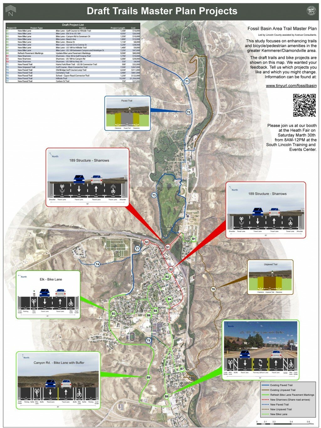
A diagram depicting potential projects as part of the Fossil Basin Area Master Trail Plan. The current plan aims to connect the existing trails in the greater Kemmerer-Diamondville area.
The Lincoln County Planning and Engineering Office is working with the city of Kemmerer, the town of Diamondville and Avenue Consultants to conduct a study of existing trails in the area and create a master plan for improvements and construction of new trails.
This study will help create a comprehensive master plan to enhance trails and bicycle/pedestrian routes in the greater Kemmerer-Diamondville area. The study will also update the Safe Routes to School plan.
The project is 80 percent funded by a grant from the Wyoming Department of Transportation and the Federal Highway Administration.
Lincoln County Engineer Amy Butler has informed the county commissioners that the plan will identify gaps in trail connectivity and barriers to creating and improving area trails.
Work on the comprehensive plan officially started in May 2018, when the Lincoln County Commissioners awarded the Fossil Basin Area Master Trail Plan project to Avenue Consultants (an engineering company based out of Taylorsville, Utah) for $39,953.
Current paved trails in the area are the Canyon Road trail and the Golf Course trail. Current unpaved trails in the area include the dirt trail at the Diamondville Fishing Pond and the gravel Hams Fork River trail.
“The paths and walks that have been developed over the years have improved conditions for pedestrians and cyclists... but do not represent a connected system or network that serves non-motorists throughout the community,” the project description reads. “A comprehensive plan is needed to guide the development of off-system paths, side paths/walks, bike lanes, shared bike routes, and recreational trails. A wayfinding system must be developed to ensure that those who wish to traverse the community on foot or a bicycle can get where they wish to go.”
The draft project list for the Fossil Basin Area Master Trail Plan includes eight new bike lanes, five new paved trails, two new unpaved trails, three new sharrows (street markings indicating where cyclists should travel) and refreshing pavement markings. The drafted project list is included below.
• New bike lanes (8): Golf course to Hillside Trail, Elk Street to US 189, Canyon Road to Sorensen Drive, Beech Avenue, Moose Street, Garnet Street to Conroy Street, US 189 to Hillside Trail, US 189 between Canyon Road and Antelope Street
• New sharrows (3): Hwy 30 to Golf Course Trail, US 189 to Canyon Road, US 189 to Hwy 30
• New paved trails (5): Hams Fork River Trail – US 30 connector trail, Old Bridge Golf Course Loop Trail, Cemetery Trail, School – Canyon Road Connector Trail, Carbon Street Trail
• New unpaved trails (2): Golf Course River Connector Trail, Hillside trail
• Refresh pavement markings
The study estimates the highest anticipated project cost to be for the construction of a new unpaved Hillside Trail. That project would total $1,356,000.
The group gathered public input on the trail plan at a home football game in October 2018 and at the Community Health Fair on March 30, 2019. The county and the consultants received surveys from August to November of 2018. The group received 94 completed surveys from the community about the Master Trail Plan.
Survey questions sought information from residents about when and how often they walk and bike in the community.
“There is a paved path next to Canyon Road, it’s very nice except that it does not connect with the town or other paths,” one survey respondent wrote. “I hate packing up the car to drive a short distance in order to go for a walk.”
Twenty-seven survey respondents indicated that they had biked or walked in the community in the last two days, and 24 respondents had walked or biked in the area in the last week. Only four respondents said they had never walked or biked in the Kemmerer-Diamondville community.
Seventy-one survey respondents said they walked or biked for exercise, 34 said it was for recreation, and 17 said it was part of their work commute. Most survey respondents said they walked and biked during the summer months from May to August.
Survey respondents seemed to agree that the current trails serve their purpose, but more connectivity between trails would be welcome.
“The routes we have now are nice, although it would be nice to have more routes to choose from,” another resident responded. “I enjoy taking in all the beautiful view of Kemmerer and its surroundings. There’s so much to see so more trails would be awesome.”
Other suggestions from the public for the Master Trail Plan included wayfinding signs to connect the area trails and more sidewalks for safe travel.
Also part of this project is the Big Spring Scenic Backway Master Plan. It addresses potential projects on the 68-mile backway that separates Kemmerer and Cokeville through the Bridger-Teton National Forest.
Ownership of the Big Spring Scenic Backway is split between U.S. Forest Service, the state and Lincoln County. The current study has identified 16 key areas on the backway:
• Hams Fork Trail - Lions Club Park
• Dempsey Road
• Kemmerer Reservoir
• Lake Viva Naughton Dam
• Lower Viva Naughton Marina
• Upper Viva Naughton
• Dempsey Point
• Mayfield/Nugent Winter Sport Area
• Snowmobiling Area
• Teddy Bear Corner
• Historic Settler Cabin
• Historic Forest Service Guard Station
• Hams Fork Campground
• Big Spring
• Access to Lake Alice
• Pine Creek Area
At a recent Friends of the Bridger-Teton public input meeting, Lincoln County engineer Amy Butler discussed improvements that could be made to the Big Spring Scenic Backway and site, including improving the road and trail access, repairing the bridge, and offering better parking and a picnic area. More information on the progress of the Fossil Basin Area Trail Master Plan, including videos of the current bike lanes on Canyon Road and the Big Spring Scenic Backway, can be found at tinyurl.com/fossilbasin.


