

Area-wide snowpacks continued to build throughout the month of April. With warmer temperatures, low elevation snowpacks are starting to melt. High elevation snowpacks have not melted much yet. Usually, high elevation snowpacks start to melt by April 11.
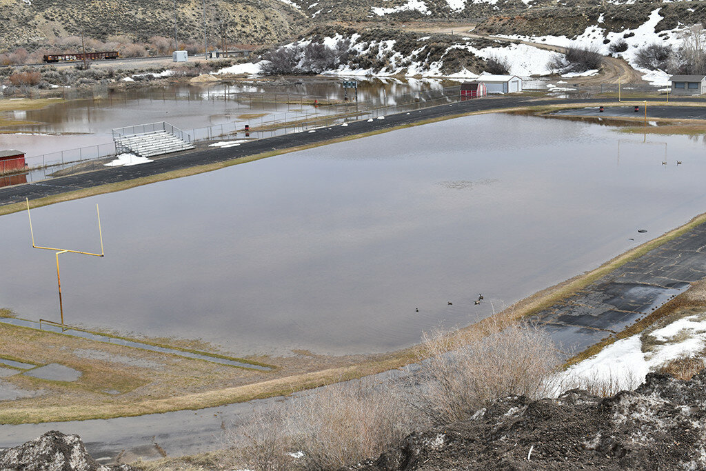
Spring is a month behind normal. This could be concerning if all snowpacks melt at the same time. If we start to lose an inch or more per day at our Snotel sites, overland flooding could become serious.
This item is available in full to subscribers.
To continue reading, you will need to either log in to your subscriber account, or purchase a new subscription.
If you are a current print subscriber, you can set up a free website account and connect your subscription to it by clicking here.
If you are a digital subscriber with an active, online-only subscription then you already have an account here. Just reset your password if you've not yet logged in to your account on this new site.
Otherwise, click here to view your options for subscribing.
Please log in to continue |
Area-wide snowpacks continued to build throughout the month of April. With warmer temperatures, low elevation snowpacks are starting to melt. High elevation snowpacks have not melted much yet. Usually, high elevation snowpacks start to melt by April 11.
Spring is a month behind normal. This could be concerning if all snowpacks melt at the same time. If we start to lose an inch or more per day at our Snotel sites, overland flooding could become serious.
As of May 1, the Snake River Basin’s snowpacks’ snow water equivalent (SWE), as a whole, was 124% of median. This is not overly concerning but there will be high water flood flows, especially due to low elevation snowpack melt. The Salt River Drainage Basin’s snowpacks’ SWE range from a high at the Grover Park Manual Snow Course at 1070% of median, which is way over median, since it is normally melted this time of the year, skewing statistical data, to a low at the Cottonwood Snotel Site at 137% of median.
The Greys River Basins’ snowpacks’ SWE range from a high at the Triple Peak Snotel Site at 128% of median to a low at the Blind Bull Summit Snotel Site at 112% of median.
As of April 1, the Greys River near Alpine most probable flow was predicted to be 115% of median. The Salt River near Etna most probable flow was predicted to be 139% of median. Salt River flows are somewhat concerning for flooding if snowpacks melt quickly. Jackson Lake, as of April 1, was 24% of capacity.
The Upper Bear River Basins’ snowpacks’ SWE, as a whole, for May 1, is 198% of median. This is somewhat problematic for severe flood, especially if low and high elevation snowpacks melt at the same time. The snowpacks in the Cokeville area range from extremely high at the Salt River Snotel Site at 219% of median and the low at the Big Park Manual Snow Course Site at 140% of median.
The head of the Bear River snowpacks’ SWE are all near record levels with a high at Hayden Fork Snotel Site with 210% of median to a low at the Lily Lake Snotel Site, which is a lower elevation site, with 108% of median.
As of April 1, the waterflow prediction at the head of Bear River near Woodruff, Utah, was around 215% of median. The Smiths Fork River near Border, is about 133% of median. Woodruff Narrows was at 28% of capacity as of April 1.
As a whole, the Lower Green River Basin’s snowpacks’ SWE for April 1 was 168% of median. Snowpacks’ SWE in the Upper Hams Fork River drainage basins ranged from a high at the Hams Fork Snotel Site at 377% of median to a low at the Indian Creek Snotel Site with 129% of median. The Hams Fork Snotel Site is one of the lowest elevation Snotel sites and is reflective of the current slow snow melt in lower elevations this year. This is concerning but not critical.
River flow prediction, as of April 1, for the Hams Fork River below Pole Creek was 132% of median.
This will be the last monthly update for snow conditions by the Lincoln Conservation District for this year. This year should bring plenty of water for everyone … perhaps too much!
Take time to prepare for possible flooding if you have experienced high water conditions in the past. It is difficult to predict flood flow levels, but this year could be amongst the records flows.
Individuals wanting more snowpack/water forecast information may contact the Lincoln Conservation District (LCD) Field Office at (307) 279-3256 or the Wyoming State Engineer’s Office in Cokeville at (307) 279-3441. A tabulation worksheet of daily statewide Snotel site measurements may be taken off the internal at www.wrds.uwyo.edu/wrds/nrcs/snowprec/wnopre.html.


